Friday 28 July 2017

Be safe online
Title
|
Be safe when you go online
| |||||
Learning Intention
|
L.I is to make a poster about Online safety
| |||||
What did you learn?
|
We learned about smart choices online and safety online
| |||||
How did you learn?
|
We learned by making a poster about how we can be safe online
| |||||
Embedded Digital Learning Object
|
Online Safety
| |||||
Labels
|
Choose the subject:
|
Choose a keyword from the learning intention. For example:
| ||||

Thursday 27 July 2017

Saturday 8 July 2017
Day #5: One Step at a Time…
Enjoy camping in this scenic reserve, surrounded by beech forest, next to the Lewis River.
Sir Edmund Percival "Ed" Hillary KG ONZ KBE (20 July 1919 – 11 January 2008) was a New Zealand mountaineer, explorer, and philanthropist. On 29 May 1953, Hillary and Nepalese Sherpa mountaineer Tenzing Norgay became the first climbers confirmed to have reached the summit of Mount Everest. They were part of the ninth British expedition to Everest, led by John Hunt. TIME magazine named Hillary one of the 100 most influential people of the 20th century.
Hillary became interested in mountaineering while in secondary school. He made his first major climb in 1939, reaching the summit of Mount Ollivier. He served in the Royal New Zealand Air Force as a navigator during World War II. Prior to the 1953 Everest expedition, Hillary had been part of the British reconnaissance expedition to the mountain in 1951 as well as an unsuccessful attempt to climb Cho Oyu in 1952. As part of the Commonwealth Trans-Antarctic Expedition he reached the South Pole overland in 1958. He subsequently reached the North Pole, making him the first person to reach both poles and summit Everest.
Following his ascent of Everest, Hillary devoted most of his life to helping the Sherpa people of Nepal through the Himalayan Trust, which he founded. Through his efforts, many schools and hospitals were built in Nepal.
Mount Everest, also known in Nepal as Sagarmāthā and in Tibetic languages China as Chomolungma, is Earth's highest mountain. Its peak is 8,848 metres (29,029 ft) above sea level.[1] Mount Everest is in the Mahalangur Range.[6][7] The international border between China (Tibet Autonomous Region) and Nepal runs across Everest's summit point. Nearby peaks include Lhotse, 8,516 m (27,940 ft); Nuptse, 7,855 m (25,771 ft), and Changtse, 7,580 m (24,870 ft) among others. Another nearby peak is Khumbutse, and many of the highest mountains in the world are near Mount Everest.
In 1715, China surveyed the mountain while mapping Chinese territory and depicted it as Mount Qomolangma no later than 1719.[8] In 1856, the Great Trigonometrical Survey of India established the first published height of the mountain, then known as Peak XV, at 8,840 m (29,002 ft). The current official height of 8,848 m (29,029 ft) as recognised by China and Nepal was established by a 1955 Indian survey and subsequently confirmed by a Chinese survey in 1975. In 2005, China remeasured the height of the mountain and got a result of 8844.43 m.
An argument regarding the height between China and Nepal lasted five years from 2005 to 2010. China argued it should be measured by its rock height of 8,844 m, but Nepal said it should be measured by its snow height of 8,848 m. In 2010, an agreement was finally reached by both sides that the height of Everest is 8,848 m, and Nepal recognises China's claim that the rock height of Everest is 8,844 m.[9]
In 1865, Everest was given its official English name by the Royal Geographical Society, upon a recommendation by Andrew Waugh, the British Surveyor General of India. As there appeared to be several different local names, Waugh chose to name the mountain after his predecessor in the post, Sir George Everest, despite George Everest's objections.[10]
Mount Everest attracts many climbers, some of them highly experienced mountaineers. There are two main climbing routes, one approaching the summit from the southeast in Nepal (known as the "standard route") and the other from the north in Tibet, China. While not posing substantial technical climbing challenges on the standard route, Everest presents dangers such as altitude sickness, weather, and wind, as well as significant hazards from avalanches and the Khumbu Icefall. As of 2016[update] there are well over 200 corpses on the mountain, some of which serve as landmarks.[11][12]
The first recorded efforts to reach Everest's summit were made by British mountaineers. As Nepal did not allow foreigners into the country at the time, the British made several attempts on the north ridge route from the Tibetan side. After the first reconnaissance expedition by the British in 1921 reached 7,000 m (22,970 ft) on the North Col, the 1922 expedition pushed the north ridge route up to 8,320 m (27,300 ft), marking the first time a human had climbed above 8,000 m (26,247 ft). Seven porters were killed in an avalanche on the descent from the North Col. The 1924 expedition resulted in one of the greatest mysteries on Everest to this day: George Mallory and Andrew Irvine made a final summit attempt on 8 June but never returned, sparking debate as to whether or not they were the first to reach the top. They had been spotted high on the mountain that day but disappeared in the clouds, never to be seen again, until Mallory's body was found in 1999 at 8,155 m (26,755 ft) on the north face. Tenzing Norgay and Edmund Hillary made the first official ascent of Everest in 1953, using the southeast ridge route. Tenzing had reached 8,595 m (28,199 ft) the previous year as a member of the 1952 Swiss expedition. The Chinese mountaineering team of Wang Fuzhou, Gonpo, and Qu Yinhua made the first reported ascent of the peak from the north ridge on 25 May 1960.[
Day #4: Swimming with the Sharks
Day #4: Swimming with the Sharks
Cook Strait connects the Tasman Sea to the Pacific Ocean. It can be dangerous and unpredictable.Cook Strait connects the Tasman Sea to the Pacific Ocean. It can be dangerous and unpredictable.
The pretty port town of Picton is your starting point for explorations of the Marlborough Sounds. It’s also a great place to shop for souvenirs.
One of the smallest marine dolphins in the world, Hector’s dolphins grow no more than 1.5 m in length.
Day #3: Wild Eyes
Day #3: Wild Eyes
Did you know that New Zealand was an island free of land mammals before us pesky humans arrived. In turn, this means a few unusual species of animals and birds evolved that that are well worth looking out for while backpacking in New Zealand.
From the alpine parrots to “living dinosaurs”, there are quite a few surprises to be found on land. Not forgetting the marine life living it up in New Zealand’s waters like the world’s smallest dolphins or super cute fur seals.
Can’t get enough of those animals? Wildlife encounters are one of the most rewarding and intriguing New Zealand backpacking experiences, which you can learn more about here.
The Curious Kiwi, a native New Zealand bird, is your tour guide for today. He is going to take you to visit the Otorohanga Kiwi House and Native Bird Park where many of his aunties and uncles currently live. The bird park is a five hour drive from Dargaville so you hit the road right after breakfast and arrive in Otorohanga at lunch time. As you walk through the birdhouse you learn about the work being done to conserve and protect the native birds of New Zealand. You decide to help out by ‘adopting’ a native animal. Visit the ‘Adopt a Critter page’ on the Otorohanga bird house website to choose one animal to adopt. On your blog, tell us the name of the animal that you chose and a little bit about them. What kind of animal are they? What do they eat? Where do they normally live? You can use Google to help you with your research.
Day #2: New Zealand by Land and Sea
Day #2: New Zealand by Land and Sea
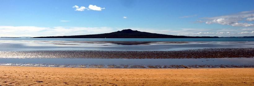
Did you know that Emerging from the sea just 600 years ago, pest-free Rangitoto Island is the youngest volcano in New Zealand. An Auckland icon and deeply enriched with history, it's long been a favourite day trip for walkers, and a much loved boating destination.
Rangitoto Island
Tane mahuta wai poua Forest


Did you know that Emerging from the sea just 600 years ago, pest-free Rangitoto Island is the youngest volcano in New Zealand. An Auckland icon and deeply enriched with history, it's long been a favourite day trip for walkers, and a much loved boating destination.
Rangitoto Island
did you know that One of Auckland's most spectacular beaches and wilderness areas, and part of the Waitakere Ranges Regional Park.
Karekare Beach
Tane mahuta wai poua Forest
Winter Learning Journey Day 1: 100% PURE New Zealand
Did you know With a patchwork history of Māori, European, Pacific Island and Asian cultures, New Zealand has become a melting-pot population - but one with some uniting features that make it unique in the world
Today, of the 4.4 million New Zealanders (informally known as Kiwis), approximately 69% are of European descent, 14.6% are indigenous Māori, 9.2% Asian and 6.9% non-Māori Pacific Islanders.
Geographically, over three-quarters of the population live in the North Island, with one-third of the total population living in Auckland. The other main cities of Wellington, Christchurch and Hamilton are where the majority of the remaining Kiwis dwell.
Day 1: 100% PURE New Zealand
Subscribe to:
Posts (Atom)